


Roche Margot

PascalBanide
User
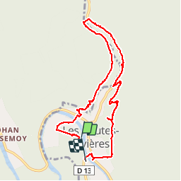

Length
8.7 km

Max alt
279 m

Uphill gradient
222 m
Km-Effort
11.8 km

Min alt
157 m

Downhill gradient
255 m
Boucle
No
Creation date :
2016-04-14 00:00:00.0
Updated on :
2016-04-14 00:00:00.0
2h27
Difficulty : Medium

FREE GPS app for hiking
 SityTrail
IGN / Geographical institutes
SityTrail Plus
The world is yours!
About
Trail Other activity of 8.7 km to be discovered at Grand Est, Ardennes, Les Hautes-Rivières. This trail is proposed by PascalBanide.
Positioning
Country:
France
Region :
Grand Est
Department/Province :
Ardennes
Municipality :
Les Hautes-Rivières
Location:
Unknown
Start:(Dec)
Start:(UTM)
632145 ; 5527292 (31U) N.
Comments